The first half of the year was packed with new features, updates and optimizations to make fieldwork with Touch GIS even more effective, efficient and reliable. In this edition of Field Notes, we’ll go over what’s changed so far this year and how you can take leverage our latest updates to save yourself time and energy in the field.
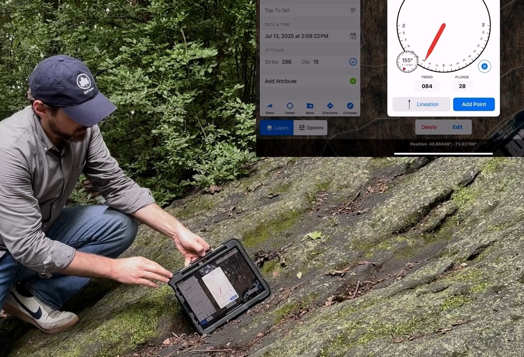
Enhanced attitude measurement
Our latest feature release adds more power and flexibility to the Attitude Measurement Tool. We’ve added the ability to measure linear orientation with trend and plunge as well as dip and dip direction for planar orientations. Check out this video overview for a full tour of the attitude measurement feature, and for a more in-depth explanation please refer to the user guide page for attitude measurement.
Other notable improvements
New features:
- The distance measurement tool now includes bearing angles between two locations.
- Photos exported in a KML are reoriented upright for easy viewing in Google Earth.
- You can now select up to 20 items from your Saved Photos at once to attach to a feature.
- Expanded support for different Spatial Reference Systems with GeoTIFF and Shapefile imports.
Recent bug fixes:
- The current location indicator is always drawn on top of all other layers.
- Photo markup correctly stays in place regardless of the photo’s portrait or landscape orientation.
- Importing data in the UTM projection for single-digit zones now correctly places the imported data.
A note on reliability:
In the field you want your tools to just work, and Touch GIS is no exception. In the past year we’ve reduced crash frequency by over 58%, a massive improvement!
I hope you’re feeling a positive difference in the field. This is the result of a continuous effort to hunt down and patch issues one-by-one. Your cooperation in reporting these issues and supplying test data has been a huge help. Please continue writing in to support@touchgis.app and provide as much information as you can to help recreate the issues on our end.
Don’t get left behind! Upgrade to the latest version (1.11.2)
1.11.2 was released on July 18th, 2025. For the best experience, make sure to download the latest version from the App Store.
Reminder: Keep your data safe by exporting it regularly.
Touch GIS does not store your map or feature data on our servers. All of your data stays on your device until exported. If the device is lost, or you uninstall the app, all of your un-exported data goes with it.
Check out this this how-to in our user guide for tips on saving your data to a cloud drive.
Introducing the Touch GIS community
I want to hear from you, and I want to make it easier to share tips, best practices, sample feature classes, new feature requests, and otherwise connect with us as well as your fellow Touch GIS users. We’ve created a Touch GIS subreddit where you can post questions, requests, suggestions, or anything else you can think of. See you there!
That’s it for the August 2025 edition of Field Notes! Thanks for reading, and thanks for your continued support. I look forward to helping make your fieldwork more effective, efficient, and enjoyable.
Cheers,
Mike